


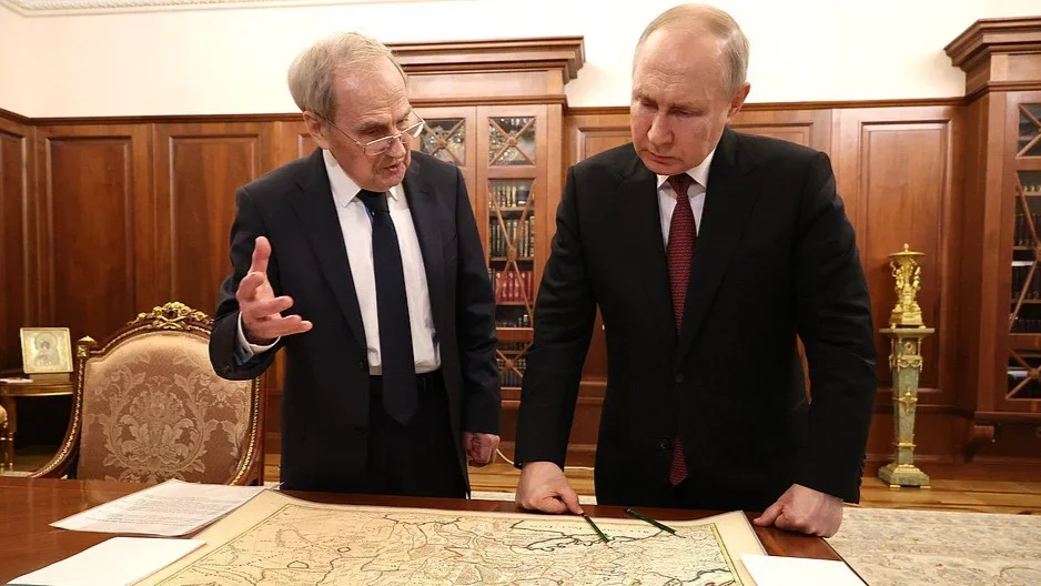
Last week, Russian President Vladimir Putin met with Chairman of the Constitutional Court of Russia Valery Zorkin. Among other things, Zorkin showed Putin a French map dating back to the 17th century which, according to him, does not include Ukraine. In turn, Putin reiterated his favourite sentiment: “It was only after the October Revolution that various quasi-states appeared and the Soviet government created Soviet Ukraine. It is a well-known fact. Before that, there was no Ukraine in the history of humankind.”
This topic was then covered on Russian TV. The next day, Russian TV host Olga Skabeyeva said that “America doesn’t exist on the maps dating back to Louis XIV’s reign either”.
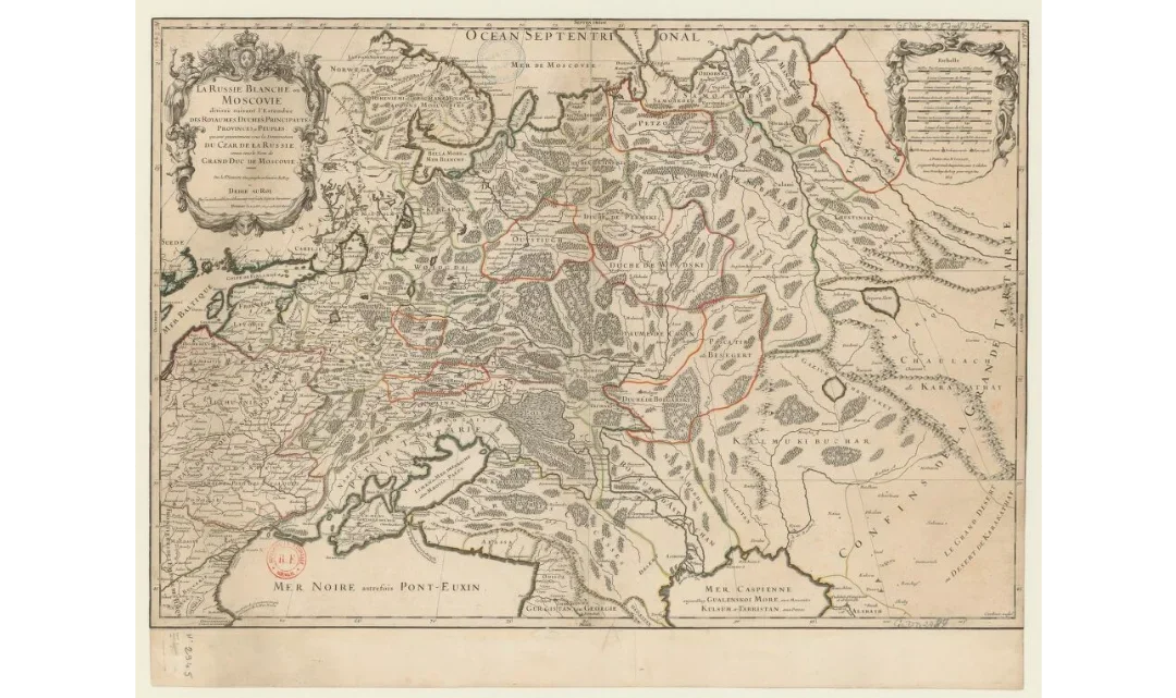
The French map by Guillaume Sanson shown to Vladimir Putin by Valery Zorkin. Source: gallica.bnf.fr
Zorkin was, to put it mildly, not quite correct. Ukraine was marked on the map as part of the Polish–Lithuanian Commonwealth. The territory stretching from Medzhybizh to Poltava is called “Ukraine, or State/Land of Cossacks”.
On the other hand, referring to old maps in order to justify modern political decisions is, at the very least, strange.
Especially if one were to remember that up until the 19th century, maps often featured outdated and approximate data. The map created by French cartographer Guillaume Sanson that Zorkin showed Putin proves this notion to the full.
Sanson divides “White Ruthenia, or Muscovy” into “kingdoms, principalities, duchies, provinces, and peoples”, while in reality it was divided into counties and quarters. The map includes the Vorotynsk, Tver, and Yaroslavl principalities which were abolished back in the 15-16th centuries.
This is completely normal for maps of that era, especially when it comes to little-known countries. Geography did not become an exact science all at once.
We can take a look at a map created by English explorer Anthony Jenkinson in 1562. There is, indeed, no indication of Ukraine on this map. But it includes Tartary / Tatary, a country that stretches from the middle reaches of the Don River to the Irtysh River. Due to the lack of information about the Golden Horde and Tatar Khanates, the Europeans of that era thought Tartary existed outside of its actual borders. Countless mentions of Tartary on 16th-17th-century maps hardly indicate that this country should exist today, especially in the outlined borders.

A 16th-century map created by Anthony Jenkinson. Source: Wikimedia
A map dating back to 1645, featured in the Atlas Maior (a 12-volume atlas, masterpiece of Dutch cartography considered a World Heritage object by UNESCO), is more precise than both the French and English maps. It features Russian borders that are correct for the time period and does not include the principalities that were abolished 200 years before the creation of the map.
These borders, obviously, do not correspond with the current borders of the Russian Federation: the North Caucasus is indicated to be Circassians’ land, while South Siberia is part of Tartary.
Furthermore, Poland and Lithuania, which joined together to become the Polish–Lithuanian Commonwealth in 1569, are marked separately.

A map dating back to 1645 featured in the Atlas Maior. Source: Wikimedia
In 1720, German cartographer Johann Homann published a map of Ukraine: Ukrania quae et Terra Cosaccorum (Ukraine, land of Cossacks). It has to be noted that in 1720, this map was also becoming outdated — the Russian Empire was in the midst of swallowing the Ukrainian Hetmanate (known as the Cossack Hetmanate — translator’s note). However, the document proves that there was knowledge of Ukraine being a separate territory in the 17th and the beginning of the 18th centuries in Europe.

An 18th-century map published by Johann Homann. Source: curiosity.lib.harvard.edu
Homann’s map is not unique. Another German map from the 18th century, which shows the theatre of Russo-Turkish wars, also indicates Ukraine and even highlights it with a separate colour, although it is shown as a part of the Russian Empire.

An 18th-century German map displaying the theatre of Russo-Turkish wars. Source: library.artstor
Of course, one can find a period when maps did not mark Ukraine at all, only showing separate provinces of the Russian Empire — those are images created in the 19th century, “the golden age of empires”. However, Ukraine is not the only state missing from those maps. For example, a French map from 1853, focused on Eastern Europe and Asia Minor, does not feature a major part of the modern states from the region, including the Czech Republic, Slovakia, Romania, Belarus, Montenegro, etc.

A 19th-century French map focused on Eastern Europe and Asia Minor. Source: gallica.bnf.fr
It’s impossible to go back to the 19th century, the era when “grand empires” divided the world into areas of influence while oppressed peoples had to accept the fact (whether they tried to resist or not). Although this era does seem to draw the attention of the Russian political leadership.
The map scene, acted out by Vladimir Putin and Valery Zorkin on 23 May, once again confirms the Russian government’s obsession with the past.
It can be affirmed that Marxist and Leninist ideologies were replaced with “historicism” or even “passeism” (obsession with the past and hostility or distrust towards the present and future — editor’s note).
Furthermore, this episode demonstrates that there are two types of states inside these people’s heads: “true”, or “historical”, and “fake”, or “non-historical”. And this “authenticity” is defined precisely by the age of the state: we’ve been here longer. However, if one were to look at those “old maps”, one could see that Russia’s borders in the 16-18th centuries are significantly different from those of today. On those maps, the North Caucasus, Siberia, or the Volga region are often not part of Russia. Thus, the concept of an “eternal Russia” is easily disproved by the document brought into play to justify its existence.
Join us in rebuilding Novaya Gazeta Europe
The Russian government has banned independent media. We were forced to leave our country in order to keep doing our job, telling our readers about what is going on Russia, Ukraine and Europe.
We will continue fighting against warfare and dictatorship. We believe that freedom of speech is the most efficient antidote against tyranny. Support us financially to help us fight for peace and freedom.
By clicking the Support button, you agree to the processing of your personal data.
To cancel a regular donation, please write to [email protected]


